There are huge mountain ranges on Earth that we’ve never seen; towering volcanoes that spew molten rock whose locations are still a mystery; enormous, gaping canyons that have gone largely unexplored. This is the sea floor—the last great uncharted territory on Earth.
Oceans cover roughly 70% of our planet—making for a whole lot of Earth that we’re not very familiar with or have never seen at all. The oft trotted out trope is that we have better (meaning higher resolution) maps of places like Mars, the Moon, or Venus that we do of our own seafloor. How is that true in this day and age?
ADVANCED AS WE ARE, HUMANS STILL CAN’T SEE THROUGH WATER.
What makes mapping the ocean different than, say the remote Tibetan Plateau or the imposing Alps, is one very simple, yet very important thing: water. Advanced as we are, humans still can’t see through water. And unlike land which, thanks to our aerospace technology, we can see in almost frightening detail, we can’t lob something into space and have it take pictures of the ocean floor. The moon is hundreds of thousands of miles away, and Mars and Venus register in the millions of miles away, but they are so much easier to map because they aren’t under water!
Early efforts to map at least some of the ocean floor—especially those parts of it near shore in busy shipping areas—began, well in the age of shipping. Throughout centuries of maritime exploration, mariners relied on sounding—using long ropes and lead weights to estimate distances—to get some sense of the ground beneath them. Though undeniably useful, this method produced only the most rudimentary picture of what was lying below the waves.
SOUND INSTEAD OF SIGHT
Medalist William Maurice Ewing was one of the first to argue for systematic mapping of the seafloor beginning in the 1930s. He labored in near obscurity using instruments built out of coffee cans and car parts until WWII. Suddenly there was a huge incentive to understand the seafloor and Ewing took advantage of it.
Maurice Ewing (left) and Frank Press (right), circa 1950. Courtesy Lamont-Doherty Earth Observatory.
Ewing quickly realized that one of the best methods for underwater mapping was using not sight, but sound. Sonar had been in use since WWI, but under Ewing it advanced by leaps and bounds. Under his direction, Marie Tharp and Bruce Heezen produced the first geophysical map of the Atlantic Ocean. Ewing also discovered that the mysterious mid-Atlantic ridge—now recognized as the largest geological feature on the planet—was actually part of a global system of volcanic mountains.
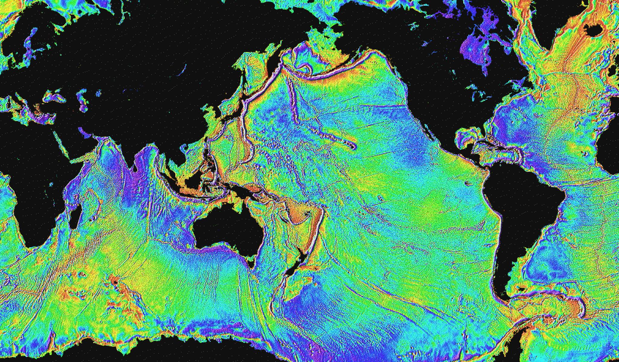
As sonar technology—which bounces sound waves off the seafloor and measures how long they take to return—improved, so did our ocean maps, but even today there are huge limitations. Modern sonar equipment can produce incredibly detailed maps with a resolution of about 100m—meaning features larger than 100m (or about the size of a football field) are visible. But, sonar can only map narrow sections of the seafloor beneath the ship the instrument is attached to, so getting a complete picture is still a laborious process. Highly detailed sonar maps are still only available for about 10-15% of the ocean floor, an area roughly the size of Africa. (For comparison, China released a map of the lunar surface in 2012 with a resolution of about 7m or 23 feet.)
SATELLITES CAN NOW PROVIDE US WITH A ROUGH PICTURE OF THE SEAFLOOR, WHILE SONAR CAN FILL IN MORE OF THE DETAILS. BUT ON THE SEAFLOOR, THE OLD ADAGE ‘SEEING IS BELIEVING’ IS AS POWERFUL AS EVER.
Though we still can’t see through water, some intrepid scientists have recently figured out a way to make use of satellites in the mapping process. Finely tuned instruments can measure incredibly small dips or bumps on the sea’s surface. Repeated measurements allow scientists to subtract factors like waves and tides thereby revealing changes that point to underwater structures.
VISION QUEST
Satellites can now provide us with a rough picture of the seafloor, while sonar can fill in more of the details. But on the seafloor, the old adage ‘seeing is believing’ is as powerful as ever. Though, like sonar, they are only capable of mapping narrow sections at one time, submersibles and remotely operated vehicles (ROVs) have given us pristine glimpses of both the terrain and life on the seafloor. They are an enormously powerful tool for bringing far away lands to life.
Despite the challenges, we’ve managed to map the entire ocean floor to a resolution of about 5km (3.1 miles). To put that number in perspective, that means that we’re now capable of seeing features on the seafloor that are as big or bigger than the distance between Times Square and the Brooklyn Bridge as the crow flies. Considering the technological challenges, that’s an impressive feat. But as anyone who has ever been to New York or looked at an aerial image of the city can tell you: there’s a whole lot to see between those two places.
I’VE GOT A BLANK SPACE, BABY
Fascinating science aside, why does it matter what’s on the seafloor anyway? The answer is that it matters for a lot of reasons. Understanding the physical layout of the ocean floor and how it affects marine life is an important step towards wise and effective management of one of our most precious—and threatened—resources. Knowing how organisms ‘manage’ an area can help us enact more sensible human regulations.
THE DRIVE TO EXPLORE THE BLANK SPACES ON THE MAP IS INNATELY HUMAN, AND THE OCEAN IS STILL ONE HECK OF A BLANK SPACE.
Ocean mapping has also opened up entirely new chapters of geological history to us. It was in the oceans that the once derided theory of plate tectonics was first confirmed, and where one can witness the birth of new crust as it emerges from rifts in the seafloor and spreads out. Understanding that process has told us much about how the Earth came to be as it is today and what it has looked like in the past.
The ocean is also home to a wealth of archaeological sites. George Bass, who won a National Medal of Science in 2001, created many of the methods still used in underwater, or nautical, archaeology. Searching beneath the waves has shown us ice age villages buried as the sea level rose. It has, of course, uncovered enormous treasure troves of the sort we all dreamed of as kids playing pirates. And of course, there is the not-to-be-ignored excitement of the Titanic, even if Leonardo DiCaprio could have fit on that piece of wood with Kate Winslet.
The need for quality, high resolution maps of the ocean floor was recently highlighted by the ongoing search for missing Malaysia Airlines flight MH370. Part of the reason the search for the wreckage has been so frustrating is that we don’t have maps with enough detail to let us see an anomaly as small as airplane debris on the vast ocean floor. Even our best maps can only resolve things larger than a football field—and they only cover parts and pieces of the seafloor.
But of course, the best reason for exploring the seafloor is perhaps the most ineffable. The drive to explore the blank spaces on the map is innately human, and the ocean is still one heck of a blank space. We should continue to explore not only because we can, but because whatever is down there holds the answers to questions we haven’t even learned to ask just yet.
Your contribution to the NSTMF not only serves to celebrate scientific advancement, ingenuity, and exploration, but also symbolizes your commitment to building a more diverse, equitable, and inclusive future in STEM.